Partnership proposal to EU tender: Copernicus for Land and Water HORIZON-CL4-2024-SPACE-01-35
The InterEcoCenter (IEC) offers a partnership with the preparation of a partnership proposal for the preparation of proposals for participation in the tender:
IEC can do the following: 1. Development of effective integrated product chains providing a holistic approach to better land use planning and hydrological monitoring and forecasting, combining and assimilating current Copernicus service products provided with a continental and global hydrological monitoring and conducting Copernicus Emergency Management and Climate Change Prediction System to Flood (CEMS & C3S).
2. Development of a general leading approach in the field of hydrological modeling to prevent the needs of floods, hydrological monitoring of climate change, forecasting of inland water rivers as short-term forecasting with corresponding climate monitoring based on existing systems of continental and global hydrological monitoring and forecasting CEMS & C3S.
Our offer will help provide flexibility for enhanced Earth monitoring for the atmosphere and climate change, and global meteorological observation in CEMS & C3S. This direction accordingly supports the key strategic orientation from the CSR Strategic Plan B "Restoring their European ecosystems and biodiversity, as well as sustainable management of natural resources to ensure food security and a clean and healthy environment." The proposals are aimed at ensuring civil safety during drives and their monitoring, to should take into account the directions of the European Science Cloud (EOSC) and the Destination Earth initiative.
We can participate in the development of proposals for the improvement of already developed procedures and products/service elements of EU Copernicus, such as the CEMS & C3S. - Mapping (EMS) and the Flood Warning System (GloFAS).
We use Copernicus Emergency Management Service – Mapping (EMS) to implement practical tasks for Flood monitoring by used next tools:
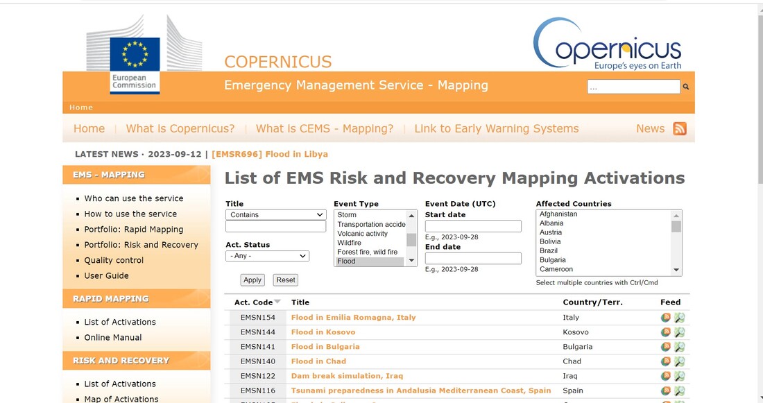
List of EMS risk mapping and recovery activations
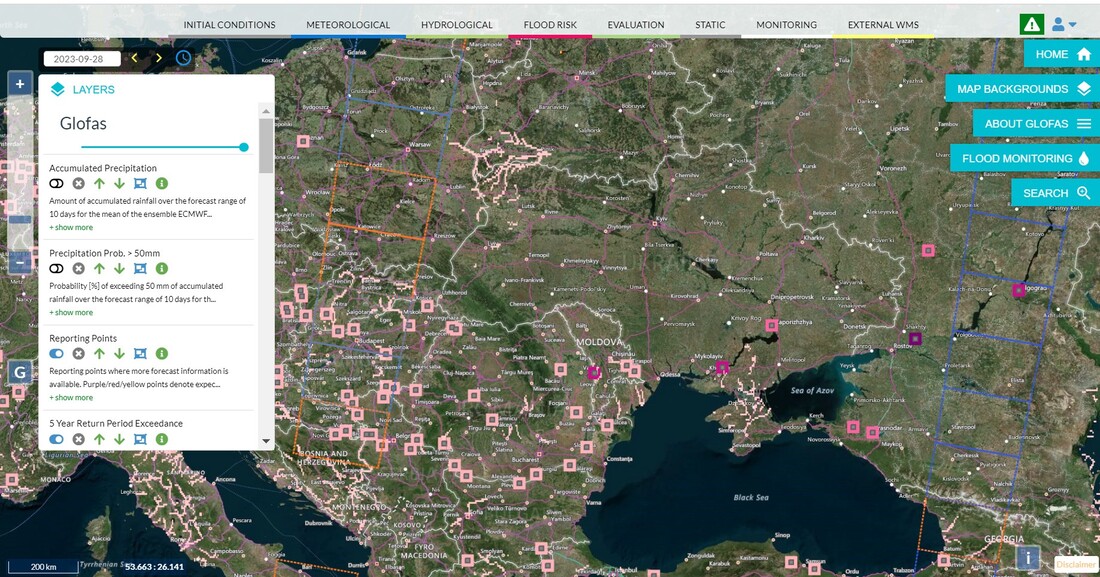
Global Flood Warning System (GloFAS) to monitoring floods in Italy 2023.
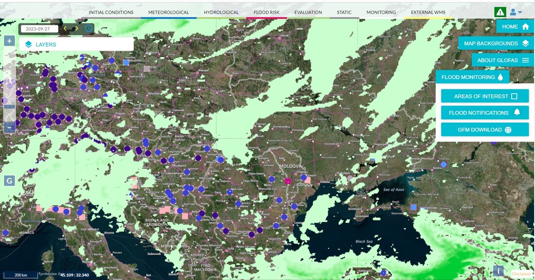
Global Flood Warning System (GloFAS) to monitoring floods in Transcarpathian region, Ukraine.
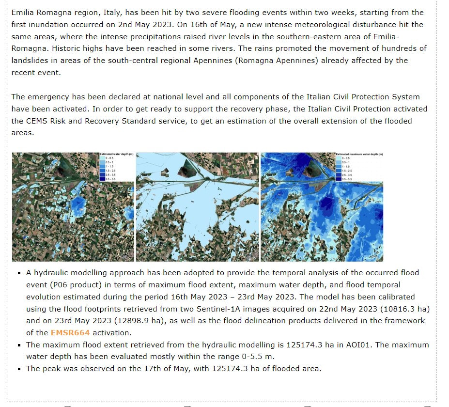
Examples of analysis of monitoring, forecasting, unification and assimilation were used on the example of monitoring flood in Italy in 16/05/2023
Analysis of models and data for flood monitoring in 2023 for Emilia Romagna region, Italy
Fig. Tool: List EMS risk mapping and recovery activations in 2023
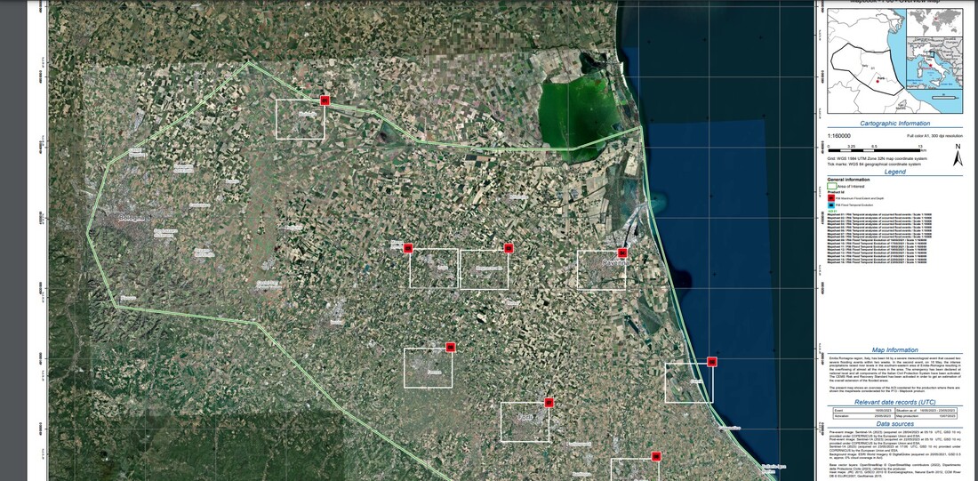
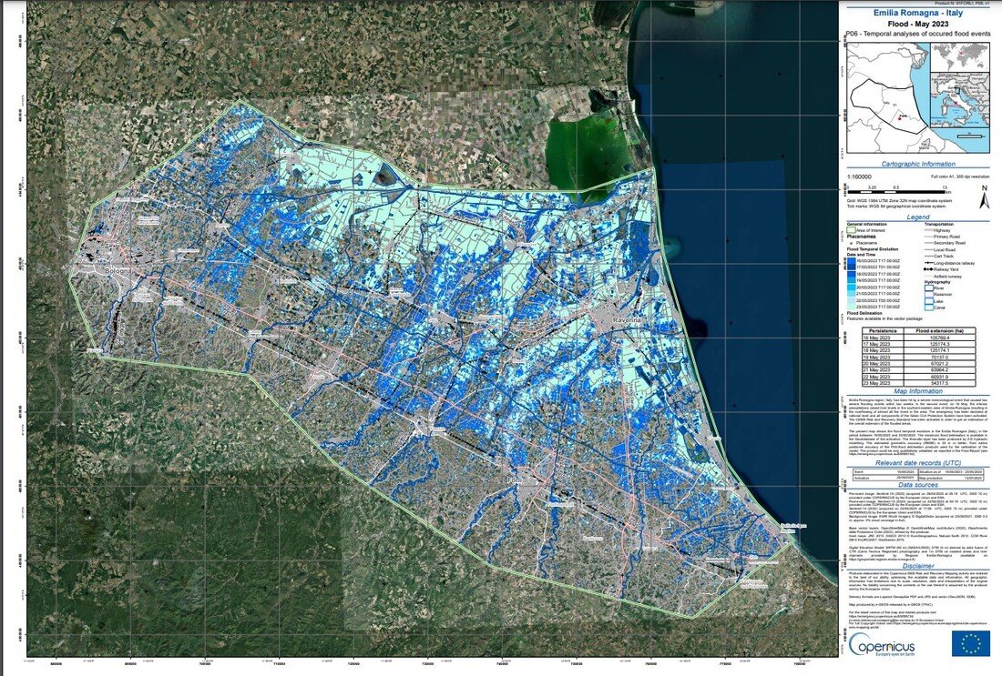
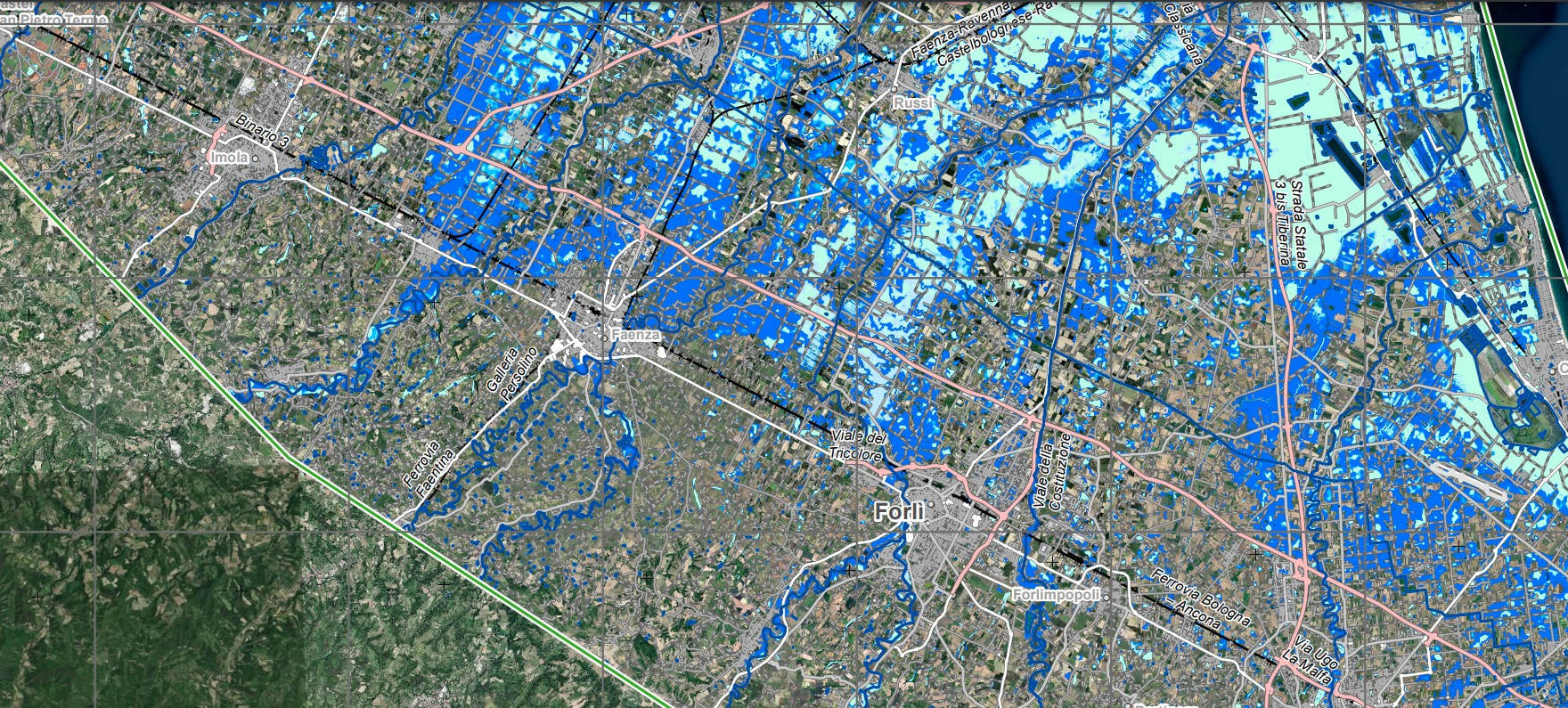
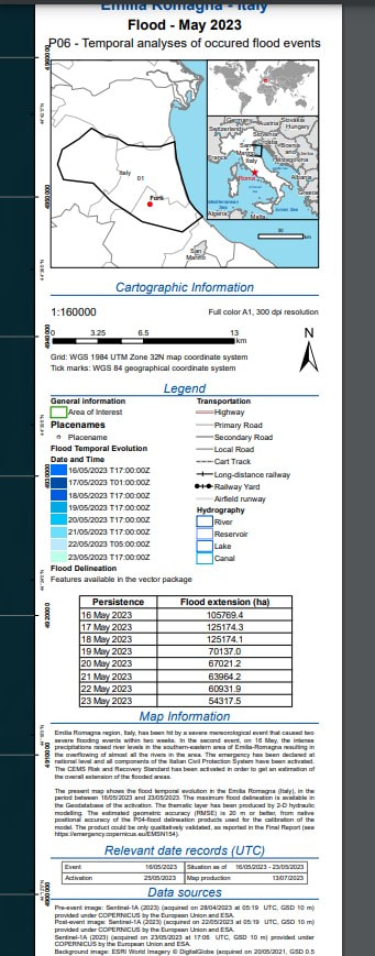
Fig. Tool: Map from EMS risk mapping and recovery activations places inEmilia Romagna region /Italy in 05.2023 with Temporal analyses of occurred flood events (on the right))
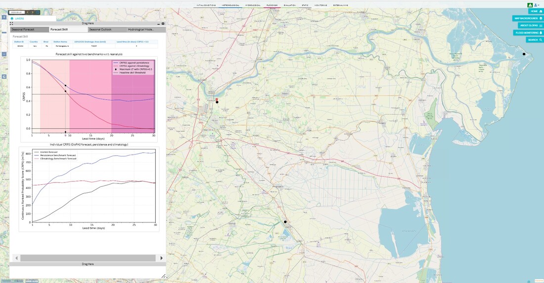
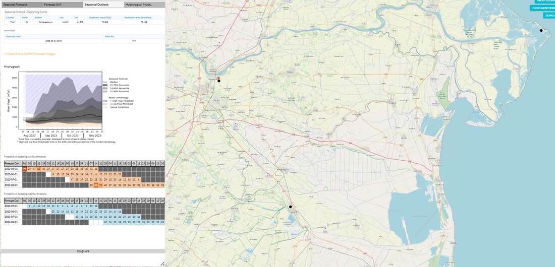
Fig. Seasonal forecast skill against climatology benchmark w.r.t. reanalysis for Emilia Romagna region /Italy. The map presents 3 reporting points for the Seasonal Forecast - GloFAS, where hydrographs are available that display the river flow forecast for a period of up to 4 months (3 reporting points - 3 black points on the map).
Fig. Forecast skill against two benchmarks w.r.t. reanalysis for Emilia Romagna region /Italy.The map presents 3 reporting points for the Seasonal Forecast - GloFAS, where hydrographs are available that display the river flow forecast for a period of up to 4 months.
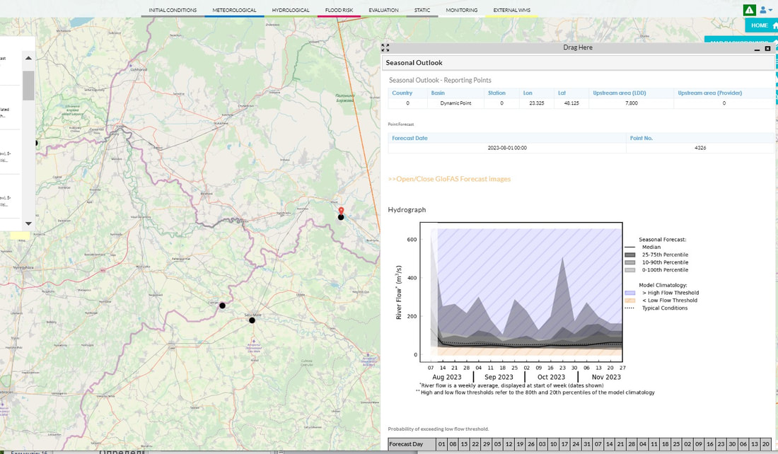
Fig. Hydrograph: Seasonal Forecast, Probability of exceeding low flow threshold, Probability of exceeding high flow threshold. The map presents 3 reporting points for the Seasonal Forecast - GloFAS, where hydrographs are available that display the river flow forecast for a period of up to 4 months.
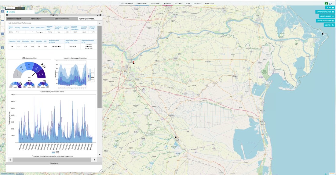
Hydrological Model Performance #1,2: KGE decomposition and Monthly discharge climatology.The map presents 3 reporting points for the Seasonal Forecast - GloFAS, where hydrographs are available that display the river flow forecast for a period of up to 4 months.
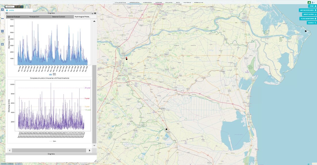
Hydrological Model Performance #3,4: Observation period time series and Complete simulation time series with flood threshold. The map presents 3 reporting points for the Seasonal Forecast - GloFAS, where hydrographs are available that display the river flow forecast for a period of up to 4 months.
Fig.Map from EMS risk mapping and recovery activations place in Italy in 05.2023 with - Temporal analyses of place occurred flood events (on the right)
Fig. Risk and Recovery Mapping Portfolio for Emilia Romagna region in model [EMSN154] Forli - Italy - Flood - May 2023/
Fig. Activation Overview for Emilia Romagna region, Italy,
Fig.Temporal analyses of place occurred flood events
Global Flood Warning System (GloFAS) to monitoring floods in Italy and Transcarpathian region, Ukraine.
Fig. Global Flood Warning System (GloFAS)
Fig. Tool GloFas-forecasting from Global Flood Warning System (GloFAS) for Italy and Ukraine
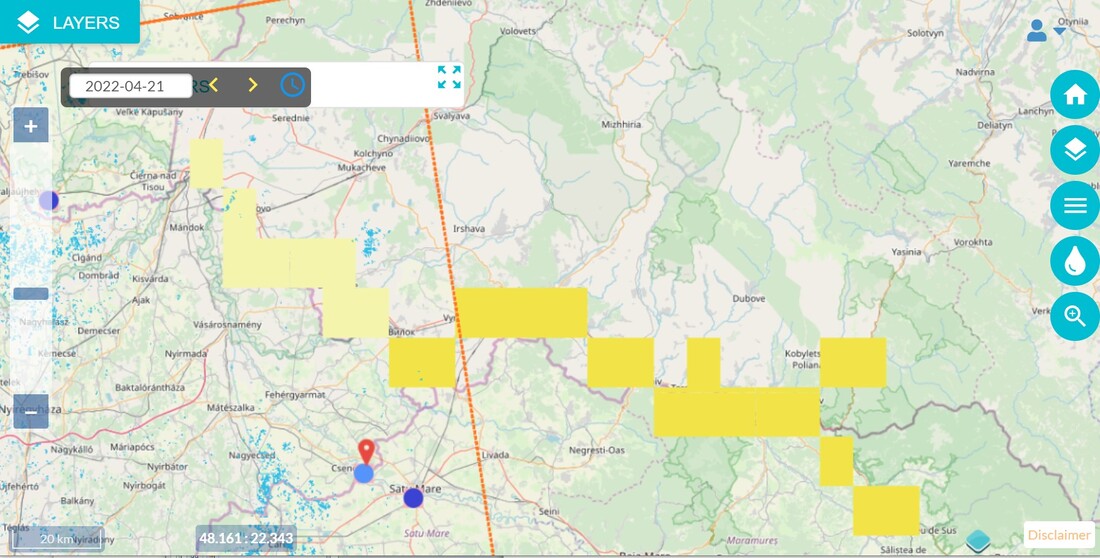
Fig. Tool: Global Flood Warning System (GloFAS) to monitoring floods in Transcarpathian region, Ukraine.
Fig. Monitoring location floods in Transcarpathian region, Ukraine it term 5 -20 years
Fig. Glofas Map Precipitation Prob. > 50mm.Probability [%] of exceeding 50 mm of accumulated rainfall over the forecast range of 10 days for the ensemble ECMWF forecast.
Fig. Seasonal Outlook - Reporting Points for GloFAS Forecast images with Point location (on the left) and Hydrograph data (on the right). Location of the Reporting Point near Khust, Transcarpathian region, Ukraine.
Fig. Seasonal Outlook - Reporting Points for GloFAS Forecast images near Khust, Transcarpathian region, Ukraine
Conclusion
We offer suggestions that can improve the visualization and presentation of data in the Global Flood Warning System (GloFas). We can state the fact of the satisfactory sufficiency of the parameters and their values for the preparation of a model with an acceptable level of significance and probability for the Emilia Romagna region in Italy, as well as for the creation of prognostic models and their processing in programs for statistical processing and data analysis. We can state the fact of low significance and probability of data and their insufficient amount for the creation of a national database for presenting GloFas, which are necessary for the analysis of floods in the Transcarpathian region of Ukraine. This fact prevents the development of models necessary for trend analysis and systemic analysis using both measured quantitative data and statistical methods.
The proposal is based on theories from scientific articles and reports:\
Analysis of scientific articles from Elseiver/ScienceDirect is world’s premier platforms of peer-reviewed literature: a.) Earth Observation for Monitoring and Modeling Land Use, b. Soil Mapping and Process Modeling for Sustainable Land Use Management; c. Land Surface Remote Sensing Environmental Modelling & Software.
Copernicus Sentinel Data Access Annual Report Y2021. A deliverable of the Sentinels Rolling Archive, Operations Maintenance and Evolution contract, this document provides an annual look at the Sentinel Data Access Service operated by the Serco Gael consortium for ESA as part of the Copernicus programme.
Copernicus programme: research & development recommendations for Horizon Europe
OBSERVER: Copernicus— Enhancing Life on Earth by Improving Quality of Life and Contributing to a Sustainable Future
Annual report 2021: "CEMS hydrological data collection Centre"
Study to examine the socioeconomic impact of Copernicus in the EUA Value-Chain Analysis for the Copernicus Earth Observation Infrastructure Evolution: A Knowledgebase of Users, Needs, Services, and Products.
Not-for-profit international scientific journal “Geoscientific Model Development (GMD)”.
It dedicated to the publication and public discussion of the description, development, and evaluation of numerical models of the Earth system and its components. The following manuscript types can be considered for peer-reviewed publication: a.)geoscientific model descriptions, from statistical models to box models to GCMs; b.) development and technical papers, describing developments such as new parameterizations or technical aspects of running models such as the reproducibility of results; c.) new methods for assessment of models, including work on developing new metrics for assessing model performance and novel ways of comparing model results with observational data; d.)papers describing new standard experiments for assessing model performance or novel ways of comparing model results with observational data; e.) model experiment descriptions, including experimental details and project protocols; f.)full evaluations of previously published models.
8. Copernicus Service service evolution 9. Copernicus services catalogue: Land Pan European/Local Land with types products 10. Roadmap for integration into Copernicus EMS operations and in other emergency related contexts 2016.